
The short answer
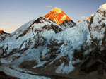
Learn the shapes. Everest is a dark pyramid behind Nuptse, Lhotse is the long wall beside it, Ama Dablam is a sharp tooth with a hanging glacier, Machhapuchhre is a twin-tipped fishtail, and Annapurna I is a broad white massif. A viewpoint map or guide helps on the day.
Key facts
- Everest
- Dark pyramid behind Nuptse
- Ama Dablam
- Sharp rock tooth
- Machhapuchhre
- Fishtail summit
- Dhaulagiri
- Big white massif
How it works
- Pick a viewpointNagarkot, Sarangkot, Kala Patthar or Poon Hill each show different ranges.
- Get a peak mapPhoto panels at viewpoints label each summit.
- Learn two or three shapesAma Dablam and Machhapuchhre are easiest.
- Check cloudPeaks appear and vanish within minutes.
- Use a guideLocals name peaks by sight.
Insider tip
Photo-panels at viewpoints and a guide naming each peak make the day easier.
Avoid this
Do not trust phone apps blindly; cloud and distance confuse them.
Related questions
Can I see Everest from Kathmandu?
Generally not; it is hidden by nearer peaks.
Which viewpoint shows the most peaks?
It depends on the range; Poon Hill and Kala Patthar are famous.
Quick trip match
Plan your Nepal trip in 60 seconds
Answer four short questions. We show trips that fit, and a planner can send a route and price. Free, no payment.
Trips that match this guide
Keep reading
More guides to explore
- Everest Trail StopsPhakding to Gorak Shep, Gokyo, the passes and glaciers.
- Annapurna Trail StopsUlleri, Ghorepani, Chhomrong, Jhinu and the sanctuary.
- Trekking and Expedition PeaksMera, Island, Lobuche, Pisang, Chulu, Yala and expedition peaks.
- Peak ProfilesOne page per peak with height, season and level.
- All Nepal guidesBrowse every place and theme.